The Au Sable River in Michigan is considered to be one of the best brown trout fisheries east of the Rocky Mountains and has been designated as a blue ribbon trout stream by the Michigan Department of Natural Resources. The Au Sable River is known at the birthplace of Trout Unlimited, for it is where George Griffith first organized TU based on the Ducks Unlimited organization. By the way if you are wondering, the meaning of Au Sable is “with sand”.
The mighty Au Sable River starts just west of I75 northwest of the town of Grayling, Michigan and flows for about a hundred miles or more through the Lower Peninsula, paralleling the Manistee River, before emptying into Lake Huron. On its way to Lake Huron, it drops some 650 feet in elevation which makes it a mild flowing river for the most part although it can be deep and treacherous in some areas.
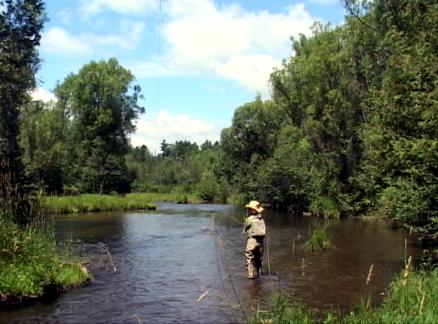
At Grayling, the main stem is joined by the East Branch of the Au Sable. Not far from Grayling, at a place called Burton's Landing, where the Graying's nine mile long, fly fishing only, catch and release section begins. This is called the "Holy Water" by locals. This special regulation section ends at Wakeley Bridge. This section is wide with a sand and gravel bottom and is fairly easy to wade. The trout can be seen holding in lies making fly fishing fun.
From the Wakeley Bridge downstream to Mio Pond, the river gets larger with more pools and a few runs. The fishing is excellent in both of these upper sections. The section from the dam at Mio Pond downstream to McKinley Bridge is managed as trophy water by the Michigan Department of Natural Resources. This water in this area of the Au Sable River is quite deep and wading is possible in only a few places, so it is best to fish this section from a drift boat.
The South Branch of the Au Sable River joins the main stem two miles east of the Wakeley Bridge. The South Branch is easy to wade and has excellent fishing including a catch and release, artificial only section from Chase Bridge downstream to Lower High Banks.
The North Branch comes in about one mile below the McMaster’s Bridge and it also has quality trout fishing. From Sheep Ranch downstream to the main stem, the water is designated artificial flies only. Fly Fishing the Au Sable River in its lower section from Foote Dam downstream to the town of Au Sable on Lake Huron is very good for steelhead and salmond. Please note that fishing for the steelhead and salmon is limited to the lower portions of the river since there are no fish ladders on any of the dams. It should also be noted that the river is large here and caution is the order of the day.
Fly Fishing the Au Sable River:
There is ample opportunity for wading portions of the river that can be accessed from bridges, and there are some areas that provide bank fishing, especially along McKinley Road. Also, there are access points where boats can be put into the Au Sable. Below Mio Pond Dam to McKinley Bridge, anglers can keep only two trout and them must exceed 15 inches in length.
Spring:
Springtime brings about the most aquatic insect hatches and some of the best trout fishing. Hendricksons are the choice of most anglers early in the year followed by the sulphurs in May.
Summer:
The hexigenia limbata known as the Michigan Caddis is a great hatch from Wakley Bridge to Mio Pond from late in May through mid June. The duns emerge during this time and will provide good fly fishing in the evenings and nights for big browns.
Fall:
Fall may be the best all around time to fish the Au Sable while enjoying the cooler weather and fall colors.
Winter:
Early winter steelhead fishing can be rewarding but also cold!
Accessing the Au Sable is easy from the many bridges tha cross the river as well as the McKinley Road. Some good points in particular are Perry Creek, Comins flats and the McKinley Bridge.


